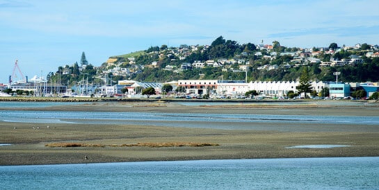
Ahuriri Estuary is one of our special places. It holds deep cultural and historical importance for local Māori and provides us with much-loved recreational opportunities. Moreover, it’s of national significance as a wildlife and fisheries habitat, providing a rich feeding ground for a diverse range of species, including intercontinental migratory birds.
Rarely is such an important ecosystem situated so close to a city centre. And with that privilege of proximity come attendant responsibilities. So are we looking after it? And who is ensuring that we do?
Safe to swim, safe to eat?
The Hawke’s Bay Regional Council takes weekly water samples at Pandora Pond over the summer months to test for faecal bacteria, and while it recommends avoidance after heavy rainfall and if there’s obvious discolouration, it deems the water quality ‘fair’ (generally suitable) for swimming.
Oliver Wade, HBRC coastal scientist, explains: “The reason the grading’s only ‘fair’ is not because of the actual results but because of the risk we’ve given to the area due to inputs and historic non-compliance” – inputs being stormwater, industrial run-off, agricultural activity upstream, high numbers of birds (associated excrement), etc.
In fact, with its ‘fair’ grade, Ahuriri Estuary currently rates the best in Hawke’s Bay in terms of recreational health, with five of the other seven monitored estuaries (from Mahia to Porangahau) graded ‘poor’ or ‘very poor’. But that’s small comfort for Māori and environmental groups who deem ongoing pollution unacceptable.
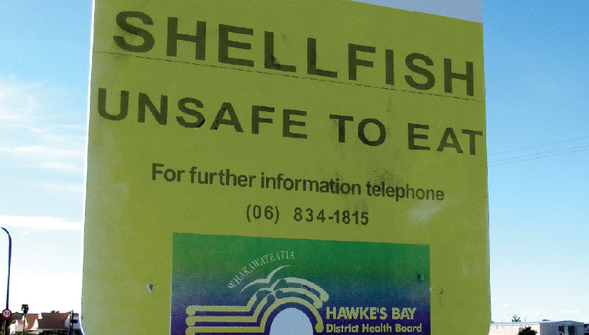
The estuary has traditionally been a kaimoana foodbasket for local hapū and whānau, and continues to be fished by Napier residents. While HBRC also monitors water quality for shellfish edibility and the estuary passes criteria for this – with Mahia and Waipatiki (both open beaches) being the only other monitored sites in the region that do – due to its urban context and the proximity of shellfish beds to stormwater drains, they take the precaution of recommending shellfish from the estuary not be consumed.
Cockles and flounder (popular estuary catch) are both sediment feeders and therefore susceptible to heavy metal contamination. HBRC doesn’t specifically analyse shellfish for contaminants, but in 2008, at Mana Ahuriri’s invitation, ecotoxologist Dr James Ataria from Lincoln University did. While he found elevated levels of heavy metals, these still fell within ministry guidelines for health: an adult would need to eat 6kg of shellfish a day to suffer harmful effects. However, as he notes, the fact that there is contamination renders the shellfish, from a tangata whenua perspective, inedible and therefore deprives Māori of their customary right.
Napier stormwater discharge
When I walked with my eight-year-old son around Pandora Pond recently, he lamented that he hadn’t brought a bucket with him to scoop off the grey oily scum from the back water behind Thames and Tyne Streets. Here one of the drains for Napier’s stormwater and neighbouring industrial activities flows directly into the estuary, bringing heavy metals, polycyclics (PAHs) and other pollutants associated with urban run-off (roofs and roads).
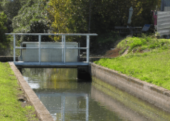
There’s a gate to shut off the outlet in the event of a major spill (such as in 1987 when Tanelith, a chemical used to treat timber, was spilled into the drainage system) but Isabel Morgan, who has passionately defended the estuary for over 40 years against development, toxic waste and further degradation, says she’s more worried about the daily accumulation. “It’s been 30 years since we first asked for contaminants to be treated at source, and nothing’s happened.”
Astonishingly, due to historical precedents, Napier City Council has not had resource consent for their stormwater discharge, and thus no formal monitoring or discharge requirements from the regional council. That said, a 2008 trade waste bylaw has tightened how industry deals with its waste, and in 2012 a new stormwater bylaw was activated to regulate what goes into the estuary.
Under the new leadership of Napier Council’s CEO, Wayne Jack, a resource consent application was filed with the regional council last December, triggering an RMA process: submissions were called for, with response from a range of environment, community and Māori groups, leading to a pre-hearing round-table discussion. HBRC put forward the conditions NCC will have to meet, which will set stringent standards around discharge quality. According to HBRC’s resource manager, Iain Maxwell, all parties appear satisfied with these.
Maxwell is confident of signing off a consent within weeks. However, as regional councillor Tom Belford observes, whether setting proper effluent conditions ‘at the end of the pipe’ will produce the desired result depends ultimately on how effective NCC’s stormwater and trade waste bylaws prove to be.
Bill McWatt, water assets manager for Napier Council, concedes there is “quite a lot to be done” to meet the consent conditions, but says the council will work hard to ensure this happens, as is their obligation. He says that the council has been working with a number of industries in the Pandora industrial area in relation to the new stormwater bylaw, and so far 11 companies have obtained approved PPPs (Pollution Prevention Plans), with a further 21 in the pipeline. Enforcement would be a last resort.
Wayne Jack says that further to regulation, they have a team working on how they can improve things, such as finding ways to capture contaminants, riparian plantings, and education (both of the public and business).
It’s bigger than the Pond
For many the estuary is synonymous with Pandora Pond, but the catchment, Te Whanganui-ā-Orotu, extends from Awatoto, Meeanee to the Poraiti hills and all the way up to Bay View, with an intricacy of freshwater networks and tidal flows. This means that addressing the identifiable issue of Napier’s stormwater is only one piece of the puzzle. There is still much to be done in even understanding the workings of the estuary, its ecological communities, and what effects we’re having both directly and indirectly, not to mention the potential impacts of climate change.
For example, HBRC monitors four sites around the estuary annually, checking sediment for heavy metal concentrations and nutrient amongst others. Data from the last five years is currently being analysed, with results to be reported within the next few months, but indications would suggest that while all concentrations are well below guideline levels, there is an increase in heavy metals upstream of the Westshore Bridge, with questions open as to where that contamination may be coming from.
The complexity of the catchment and the overlapping jurisdictions and agencies involved also means that answers as to who is responsible for what, under what terms of reference and investigation, and how we proceed, remain murky at best.
The Ahuriri lagoon once covered an area almost eight times the size it is now. Oliver Wade says “the dynamics have been changed so hugely, it really bears no resemblance to what it did 80 years ago.” With European settlement came land reclamation and drainage, while the 1931 earthquake’s dramatic tectonic shift raised the seabed by two metres, reducing the estuary by a third. Post-the-quake, Tuteranuku and Matawhero islands (of spiritual significance to Ahuriri hapū) were levelled for fill to create the airport and Maraenui, and large rivers, such as the Tutaekuri which once flowed into the estuary, were diverted.
Wade sees a problem with defining the benchmark, “Where’s our beginning point? For example, ‘restoration’ – what are we restoring? We haven’t got a clue how it was originally.”
Nonetheless, the remaining estuarine area is one of the most ecologically valuable in the country, and Isabel Morgan believes we should be doing all we can to keep it clean. “We are fortunate to have the estuary; we’ve got to look after it.” She says the Ahuriri Estuary Protection Society (established 1981 – an umbrella group for a number of environmental and community groups, including Forest & Bird) has been waiting a long time for a draft management plan they can constructively comment on.
A game-changer in this respect is Mana Ahuriri Inc., the entity representing the seven Ahuriri hapū with claim to Te Whanganui-ā-Orotu, who are on the verge of signing off on their Treaty settlement. As part of their $20 million-plus claim, MAI have successfully negotiated for kaitiaki status, including $500,000 to assist in the management of the estuary; this places them in a pre-eminent role for future decision-making.
Estuary management plan needed
Piri Prentice, chair of Mana Ahuriri, says last year when they called together the councils and various entities involved to find out where we’re at with the estuary and what’s happening, they were surprised by what they perceived as “a total lack of coordination. The entities were saying to each other, ‘I didn’t know you did this, I didn’t know that was our responsibility’ – it was amazing!” He says it was apparent to everyone at the table that there was need for a collaborative approach.
As part of their Treaty settlement terms, Mana Ahuriri are in the process of establishing a stand-alone, multiparty, statutory committee – the Ahuriri Management Committee (AMC) – to manage the Ahuriri, with the express priority of coming up with a comprehensive management plan for the estuary. It will be permanently chaired by Mana Ahuriri, and is made up of eight members, with four representatives from Napier City Council, Hastings District Council, HBRC, and the Department of Conservation, and four from MAI.
Napier Council’s Wayne Jack has proposed a model of estuary management based on the successful case of Lake Macquarie, New South Wales. Effectively an estuary three times larger than Sydney Harbour, Lake Macquarie faced similar issues with urban and agricultural run-off and severe degradation. But within a decade of implementing a comprehensive collaborative management plan, with strong input from indigenous groups, the water body became an award-winning example of effective environmental practice. Jack says “it’s a similar concept to what we want to apply here to the Ahuriri catchment.”
Piri Prentice has been impressed by the councils’ positive approach, and is hopeful that the committee will achieve a good outcome. He wants the estuary to receive full recognition –“the lot: environmental, cultural, historical” – but above all he wants to see action.
Meanwhile, the regional council-sponsored TANK group are also working through a collaborative process towards clarity around the estuary. Made up of 30 stakeholders from a wide range of organisations and tangata whenua groups, TANK has been tasked with reviewing land and fresh water management in the Tutaekuri, Ahuriri, Ngaruroro and Karamu catchments, and connected to all, the Heretaunga aquifer system. They are scheduled to provide their initial recommendations to HBRC by September next year.
Mana Ahuriri did have a place at the TANK table, but stepped down last year. HBRC’s strategy and policy manager, Gavin Ide, says they will need to find different ways to engage Mana Ahuriri in the TANK process, but how that engagement happens is an open question for both parties.
So how do the separate TANK and Ahuriri management paths converge? There’s an overlapping of organisational representation between the Ahuriri Management Committee, the Regional Planning Committee and TANK. “So hopefully through that connection, we can pass messages from one to another without the left hand working in total isolation and then coming up with something at the 11th hour and totally undermining or cutting across what the right hand is doing.” While there’s always the risk of this happening, Ide sees that “good community engagement can act as a mitigating factor.”
In any case, the Ahuriri Management Committee will expect to ratify any plans that come through the TANK process in relation to the estuary, and the TANK group will need to have regard to any planning documents ACM come up with. Either way, plan changes will need to be finalised by the Regional Planning Committee (made up of nine council representatives and nine Treaty claimant groups) and go through the full RMA submission process.
Gavin Ide: “It’s a matter of making sure all the ships are heading in the same direction and that everyone can dedicate some time and resource to whichever direction is needed,” a view wholeheartedly endorsed by Piri Prentice.
A somewhat confusing situation to be sure, but at least Mana Ahuriri, the Regional Council, Napier Council, and other committed parties are voicing the same aspiration for Ahuriri: that we can swim in the estuary and eat the food from its waters.
That seems a pretty straightforward benchmark. Can we get there in ten years, as in the case of Wayne Jack’s Lake Macquarie model? Only if, in Piri Prentice’s words, we “get on with it!”


I am sincerely hopeful this is the start of a good news story for the vital eco-system that is our estuary.
Thank you for reporting about this issue.
A message for PIRI PRENTICE – Re Ahuriri Rock Pools Development. Could Piri please contact me at his earliest convenience. Many thanks.. 021 50 66 90