In terms of the multitude of foreseeable adverse impacts of global warming, perhaps none is more ominous to this island nation than sea rise and increasingly severe storm events that will endanger and, in some cases, inundate our coastal communities and our natural and physical assets.
The Parliamentary Commissioner for the Environment in 2014 put sea rise at 20 cm in the last century, with another 30 cm predicted by 2050. The latest international science consensus is moving the 100-year planning target from a metre rise to 1.5 metres.
But now, with latest studies estimating a 93% chance that global warming will exceed 4degrees by the end of this century, the sea rise scenario looks to worsen dramatically. Says Victoria University climate professor Tim Naish, “If we don’t stabilise temperatures at 2 degrees C, we could commit the planet to 5.6 metre sea level rises.”
In response to this threat, since 2014 a group of Council staff (Regional, Hastings and Napier), consultants and community stakeholders have been working to get their heads around this inescapable challenge. Their aim: to produce the Clifton to Tangoio Coastal Hazards Strategy to address the twin long-term threats of coastal erosion and coastal inundation.
The assignment has been daunting if for no other reason than human nature. Voters are prone to complaining that politicians can’t see beyond their next election; but the fact is, most voters have difficulty with long-time horizons as well … like planning tomorrow night’s dinner or, more seriously, preparing for what our job might look like (if it still exists) in 10 years time.
In this case, how do we prepare for a set of local and planetary consequences that we are rapidly losing the opportunity to avoid, and therefore must plan to adapt to?
The group has worked through three stages – first, defining the problem as it will present right here in Hawke’s Bay; second, developing a decision-making process that must encompass reflection on science, on risks, on response options, on values and costs – all while including lay representatives of the community together with required experts; third, using this process to actually identify preferred response paths to be tested with the broader public and elected officials.
And that’s where the process stands now – ready to put preferred responses on the table for public input, and to address the myriad of implementation and costing issues involved in translating the paths selected into shorter-term actions.
At the cellular level
We’re not talking about microbiology here! In briefest terms, the approach has been to break down the Tangoio to Clifton coastline (other parts of Hawke’s Bay to follow) into 16 cells or units – each reflecting unique physical conditions and risk factors. Two community Assessment Panels (consisting of about 30 members) – Northern and Southern – were formed to work with Councils’ staff and the outside experts to evaluate the situation in their respective areas.
Based upon assessment of risk in the near-term, the highest priority cells were identified to be: Whirinaki, Bay View, Westshore, Pandora, Ahuriri, East Clive, Haumoana, Te Awanga, and Clifton.
For each of these cells, the nature of the risk was established more precisely.Alternative response paths over three time frames – 0 to 20 years, 20 to 50 years, 50 to 100 years – were examined, preliminary preferred paths were identified, costed in broad terms, then re-evaluated with a final preferred pathway established for public input and more detailed development.
For each cell, the range of alternatives considered included: do nothing, more modest interventions like beach renourishment, control structures like groynes or sea walls, ‘retreating’ to more defensible coast lines, and managed retreat … the latter involving moving people, homes and other assets out and relinquishing the areas to nature. Each response was considered for each of the three time frames. The results are shown on the opening map.
For each of these cells, the Assessment Panels have defined specific short-term actions that need to be incorporated into the overall response plans. These include steps like more immediate beach crest protection or limited vehicle access in some areas, monitoring the erosion threat to ‘lifeline’ assets between Westshore and Bay View, or providing more immediate rock protection at Haumoana’s Cape View Corner.
Assessment Panels

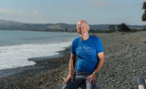
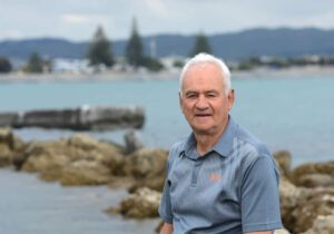
Members of the two Assessment Panels consisted of a mix of coastal residents, like Mike Harris, a retired doctor living in Haumoana, to individuals representing affected interests, like Craig Daly of the Ahuriri Business Association. All served as volunteers, and the workload was massive. Heaps of technical material to digest and a dozen three-hour after-hours workshops to engage with consultants and each other and make by consensus all the key decisions about values to protect and mitigation measures to undertake over a 100-year timeframe. I interviewed Mike and Craig, both of whom estimate they’ve spent easily over 100 hours on the project.
Mike sees climate change as ‘one of the most pressing issues of the day” and was eager to contribute to the work on the issue. He worries about ‘a lack of long-term views in a world dominated by short-term agendas’ And in the case of climate impacts, notes “it’s especially hard for people to get their heads around the long term”, perhaps creating a bias toward short-term actions.
He tilts toward preserving the natural character of the coast and accepting the power of nature, favouring long-term retreat as opposed to ‘hard engineering’ approaches, and aligning himself with the Maori view of “guardianship and stewardship as opposed to ownership at all cost … Nature can pay you back big time if you encourage it in the right direction.”
‘Despite his cynicism about much public consultation’, Mike is ‘pretty satisfied and impressed’, regarding the process as ‘robust, fair and well-intentioned” with plenty of access to the technical team on offer … “that’s been marvellous”.
How would Mike improve the process? “We’ve had a fair shot at presenting our views … and alternative views have always been accommodated”, but he would have welcomed more ‘breathing space’ for reflection on the information before making decisions. Both the overall work schedule and individual meetings were quite compressed.
Craig Daly, a transportation design engineer, shares Mike’s positive assessment and believes his panel colleagues would agree. He calls the process “daunting, exciting, at times apprehensive and overall very good … things have been put before the panels, argued out in a really robust way, and along the way all of us changed our minds about something … in most cases ending up with unanimous decisions.”
The substantive shift Craig observed was that preferences in his panel shifted from ‘managed retreat’ approaches to engineering options. For him, “The biggest thing to come out of this is that the pathways are quite flexible if, for example, sea rise is greater or timelines slide from what’s presently projected.”
He believes the panels should have a continuing role.
The panel members have made an outstanding contribution to the community. Says HBRC Councillor Peter Beaven, who’s chairing the process: “The panelists see benefit in what they’ve done, they’ve gained useful knowledge … they’ve chewed through an amazing amount of information, and it would be helpful to engage further with them as the implementation phase rolls out.”
Asked what weight the panels’ recommendations would carry, Peter responds: “I would like to think in light of the robustness of this process that Councils at the very least would take the recommendations coming before them with a great deal of seriousness, because in almost every case they are unanimous recommendations and they’ve gone through a far more robust process than a Council would normally go through itself.”
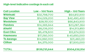
Without at this point (understandably) delving into detailed implementation plans, the working group has developed high-level indicative costings for each potential pathway in each cell, and in each time frame.

Not surprisingly, the cost ranges vary considerably. Above are the ranges for the preferred options in the priority cells.
Now what?
First of all, the broader public needs to digest and reflect upon the work done to date by the technical advisers and Assessment Panels. All this information will be provided early in the new year.
And for that matter, anyone wishing to delve into the reports completed to date can do so at the project website: www.hbcoast.co.nz. In addition, a mapping tool has been developed to show the newly mapped hazard extents. This information is at: www.hbemergency.govt.nz/hazards/portal
Of course a key aspect of the financial work to be done is fleshing out what these mitigation and adaption measures will cost individual ratepayers … and how the burden will be allocated to private individuals with properties at risk versus other ratepayers. More on the politics of ‘who pays’ in a moment.
This level of analysis cannot be completed in time to be included in Councils’ long term plans (LTPs) in the first half of next year. Ratepayers can expect, however, that their Councils will be proposing to continue to roll forward with the planning process, to the tune of several hundred thousand dollars total.
In addition, the Regional, Hastings and Napier Councils are contemplating each an initial contribution to a ‘Coastal Response Contributory Fund’ that would be intended to begin accumulating reserve funds. These funds would be earmarked for:
• Recovery from extreme weather events relating to the coastal environment in the region;
• Making safe and good the areas of abandoned and or unmanaged retreat; and,
• District/regional planning costs relating to possible changes to the coastal hazard strategy.
This seems a prudent initial funding step to take, considering a potential 100-year price tag of $140 million to $304 million! Of course, one might hope that a succession of central governments would eventually come to the funding party given the national scale of the predicament, and our Councils are committed to pursuing such funding.
Once response pathways for each cell have been finally selected, Councils will need to design specific workplans, deciding which mitigation steps should be undertaken (and financed) first … remember, it’s a 100-year strategy. The bulk of this work will fall to the Hastings and Napier Councils, whose physical assets and coastal ratepayers – will be most threatened over time. The Regional Council might be more expected to undertake aspects of the strategy that involve environmental mitigation, such as protection of beach crests and establishment of wetlands.

Yet to be determined is whether from this point on each of the Councils will make their own decisions as to which pathways to prioritise and fund, or whether the existing Joint Committee (with representatitves from Regional, Hastings, Napier Councils) will formulate a ‘master plan’ to implement a regional strategy. Beaven reckons that a key factor to consider in continuing a regional overview is that the coastline does not respect political boundaries, and actions taken in one cell can impact the others. To him, the critical question is: “How much of the autonomous decision-making power that the three Councils hold are they prepared to let go in the interest of working together?’
Politics of ‘who pays?’
If the proposed pathways are reasonable responses to nature’s threat, the question remains, who pays?
Not surprisingly, Councils are hoping for central government assistance. And Councillor Beaven notes this is another reason for Hawke’s Bay Councils to present an organised united front. The new government seems aware of the national scope of the financial challenge ahead, but it’s too soon to know what specific funding commitments, if any, might emerge.
But our Councils are determined to be ‘first cab off the ranks’ and believe the collaborative process undertaken to date will help position the region strongly. As Beaven notes, this rationale is a “key driver for getting started with the Contributory Fund as evidence that we have our s**t together.”
The next ‘who pays’ issue is intergenerational. Past and current generations have caused the problem, but future ones will bear the vast preponderance of the consequences. When Councils begin to spend serious capital on climate adaptation, monies will be borrowed over decades. But meantime, the temptation might be to defer spending because impacts are deemed 20, 50 or 100 years away. Beaven believes there are steps that need to be taken now and Councils would be “remiss” not to do so. A challenging ethical issue for our community to address.
Then there’s the most immediate pocketbook question: how much of the adaptation burden should be paid for by those living on or near the coast and most immediately affected, and how much by other ratepayers who might feel little or no direct impact? For those latter ratepayers, what is the ‘public good’ to which they should be expected to contribute? Should there be a ‘blanket’ public/private split (like the 60/40 split that has been floated), or might the answer depend on the specific actions to be taken – eg, building a sea wall for Clifton might yield a different answer than moving a wastewater treatment plant.
And the actual mechanics of setting and collecting rates – with multiple Councils tapping the same ratepayers for interventions that might cross jurisdictional boundaries – will be a complicated matter to resolve.
So, all in all, quite a collection of vexing issues for Hawke’s Bay ratepayers to get their heads around. But as you loll on the beach this summer, I urge you to think about them, for they’re heading your way with no less certainty than global warming itself.

